 The Harlem River Drive takes its name from the river it follows. Known as Muscoota to the American Indians, the Harlem River runs roughly eight miles from the Hudson River to Long Island Sound. In 1895, the Army Corps of Engineers constructed the Harlem Ship Canal to ease shipping around Manhattan. Its construction separated Northern Manhattan from the Bronx.
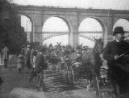
The Drive originated as the Harlem River Speedway, which, in its heyday, attracted leisure lovers from all over the country. In addition to area attractions such as Highbridge and Fort George Amusement Park, the Speedway offered beautiful scenery and recreation from the late 19th century into the early decades of the 20th century. Horse owners raced here until the increasing number of auto drivers won out. Still, only “pleasure cars” could ride the road from 155th to Dyckman Street.
Speedsters, headed for a game at the Polo Grounds, parked at the northern end of the drive near where the Polo Ground Houses now stand. Marked by the cliff of Coogan’s Bluff, named for 1899-1901 Manhattan Borough President James J Coogan (1845-1915), the Polo Grounds housed several New York sports teams until 1957, including the Giants. Baseball fans supplanted polo fans who had cheered at games from 1876 until 1883 when another team, the New York Metropolitans (Mets) took over the arena.
 19th-century New Yorkers enjoyed equestrian sports of all kinds. People raced horses in the afternoons and on weekends on avenues all over the city, yet the speedway drew in more tourists. Postcards advertising the speedway can be found at many antique shows now, though only the ghost of its tracks exist today along the east river bordering Highbridge Park. The later extension from 125th Street to Second Avenue came in 1946. Parks acquired the land by condemnation in 1873 to lay out the City’s first major highway. The two-and-a-half-mile stretch first opened to high-class horse drawn vehicles in 1898.

Riding was a major sport for drivers and spectators alike at that time. By barring commercial and business “carts,” the City set the road aside as leisure ground for aristocratic New Yorkers, who needed an appropriate surface for racing and displaying their livery. Vacationers and city dwellers would line the drive by the waterfront. In season, spectators could view collegiate boat races on the river. As Manhattan’s population grew, so did the crowds at the Harlem River Drive. When the volume of traffic reached a critical mass, residents of Washington Heights grew frustrated and demanded full use of the drive. As a result, it was paved and opened to general traffic in 1922.
By the start of Robert Moses’s (1888-1981) reign as Parks Commissioner in 1934, the Drive needed improvement. In 1940 Moses envisioned a highway that would connect the entire circuit of Manhattan’s high-speed driveways. The six-lane Harlem River Drive would link the Henry Hudson Parkway, the George Washington Bridge, and the East River Drive. Traffic from the Triborough Bridge and the several bridges joining the Major Deegan Expressway in the South Bronx would feed into the Drive. Sections of the old speedway in the path of the proposed highway would be incorporated. Estimates for the project hovered around $20 million, but the final sum came to $38 million. Construction ended in 1964, coinciding with the New York World’s Fair in Flushing Meadows-Corona Park.
