 There has been much speculation concerning the origin of the name “Spuyten Duyvil.” Dutch in origin, Spuyten Duyvil can be translated in two ways, depending on the pronunciation. One translation is “Devil’s whirlpool,” and indeed, sections of the creek were sometimes turbulent during high tide. The second interpretation is “to spite the Devil.” This translation was popularized by Washington Irving’s story in which a Dutch trumpeter vowed to swim across the turbulent creek during the British attack on New Amsterdam “en spijt den Duyvil (in spite of the Devil).”
Running from the Hudson River to the Harlem River, the Spuyten Duyvil Creek marks the northernmost tip of Manhattan Island. The creek’s significance is revealed through local Native American legends, an era of Dutch settlement, and laborious years of altering its natural course for commercial purposes. Eventually renamed the Harlem River Ship Canal (also the U.S. Ship Canal), this tidal strait has splendid views, and a variety of wildlife that still thrives despite years of human-induced change.
Lenape Indians inhabited the area for thousands of years. A Lenape settlement once stood on the Bronx side of the creek, in the area above where Columbia’s huge letter C can be seen today. Columbia University rowers painted the letter C for themselves and for their school’s teams, which play at Baker Field/Wien Stadium across the creek. The Lenape Indians called the banks of the Spuyten Duyvil Shorakapok, which has commonly been translated as “the sitting down place” or “the place between the ridges.” With an abundance of oysters, fish, waterfowl, and a diversity of other creatures, this region was an ideal hunting and fishing ground for the Lenape. Additionally, they relied on the innumerable freshwater springs that meandered throughout the vast wetlands.
 Written accounts of the creek first appear in the year 1609, when Henry Hudson and his crew may have briefly anchored their ship, Half Moon, in the Spuyten Duyvil. During the colonial period, many Dutch farmers and merchants found it convenient to cross the Spuyten Duyvil rather than pay for ferry service across the Harlem River at 125th Street. In 1669, to prevent people from crossing for free, Johannes Verveelen moved his ferry to where West 231st Street and Broadway now intersect. In 1673, Frederick Philipse replaced the ferry with a toll bridge known as the King’s Bridge. Reacting to both the fee and the occasional inconvenience of using this bridge, a Dutch landowner named Jacob Dyckman raised funds to construct the Free Bridge in 1758, which was later destroyed by the Continental Army while fleeing the British during the Revolutionary War.
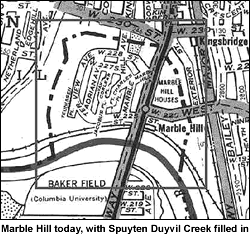
The present course of the Harlem River Ship Canal differs greatly from the Spuyten Duyvil Henry Hudson once visited. To make it more navigable, the Army Corps of Engineers began to modify both the creek and its adjacent land in the latter part of the 19th century. In 1876, the New York State Legislature decreed the construction of the Harlem River Shipping Canal. When completed in 1895, the canal severed Marble Hill from Manhattan, creating an island with Spuyten Duyvil Creek as its northern perimeter. The new channel effectively shortened the water route between the Hudson River and Long Island Sound by 14 miles. Soon after the canal’s completion, builders filled Spuyten Duyvil Creek, thereby connecting the island to mainland Bronx. Since the turn of the century, Marble Hill residents have successfully petitioned to remain within the governance of Manhattan; interestingly, for years telephone directories listed residents in both Manhattan and the Bronx.
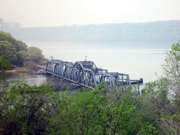
Today, the Broadway Bridge, the Henry Hudson Memorial Bridge (opened on December 12, 1936, as part of Robert Moses’ controversial “West Side Improvement” project), and railroad swing bridge, used by Amtrak passenger trains, still span the waterway.
